Featured

Welcome to the Kensington and Chelsea London Cycling Campaign Blog

We are simply people who live, work, or commute through the Royal Borough of Kensington and Chelsea who want better cycling in the borough and in London as a whole.

You can find us on twitter @RBKC_cycling and join our mailing list here

A 20mph Borough? Speech to Council by Cllr Robert Thompson

We are collecting support to ask the ruling party on Kensington and Chelsea Council (the Conservatives) to do more to support Space for Cycling. Please sign the petition now.

At a recent Council debate on cycling in the borough, Cllr Robert Thompson, a Space for Cycling supporter, spoke in favour of a number of measures to improve cycling in the Royal Borough, including introducing a 20mph limit. Below is what he said.

Speech in Favour of the Motion on Road Safety at RBKC Full Council 03/12/14
Cllr Robert Thompson, Labour Group Public Realm Spokesperson

Original Motion

This Council is very concerned to see that last year 64 people were killed or
seriously injured in RBKC; this is 64 too many. Two-thirds of accidents
involve cyclists and pedestrians. Most of these accidents are caused by
speeding and/or inconsiderate drivers of cars, delivery vans and
construction lorries. The problem of racing mopeds and super-cars is also
prevalent in certain areas.
This Council therefore commits to a review and upgrade of its target to
reduce fatal and serious accidents by one-third by 2020 and to introduce
the following:
• Immediate and enforced imposition of 20mph speed limit on all borough
controlled roads, and dialogue with TfL to implement a 20mph speed
limit on red routes;
• Dedicated cycle lanes on all other major roads where supported by
London Cycling Campaign and incorporate the west-east Cycle
Superhighway;
• Immediate review of accident black spots, particularly in relation to the
placing of pedestrian and pelican crossings and of mini-roundabouts;
• Campaign to require government to enforce retrofitting all lorries with
reversing beepers and wide side mirrors within 12 months;
• Proper monitoring and control of speeding and joy-riding mopeds, cars
and super-cars, this to be a requirement of our borough-funded PCs.
Mover: Cllr. Dent Coad
Seconder: Cllr. Bakhtiar
Amendment to Motion

‘To delete all words after “this is 64 too many” in paragraph one through to the end of the motion, replacing them with:
“This Council notes that this figure may be compared to the annual average of 101 in the period 2005-12, a reduction of 37% compared with a fall of 31% for London as a whole over the same period.
This Council resolves to continue its successful campaign to reduce road casualties and in particular:
•       to provide cycle training to adults and school children, to continue the accredited training programme for HGV drivers and to continue with our awareness training campaign, as the best way to prevent future accidents.
•       to support the traffic orders proposed by London Councils and the Mayor to make cycle safety measures mandatory on all vehicles over 3.5 tonnes.
•       to consider proposals for cycle lanes, taking into account of the interests of pedestrians, especially the disabled, bus passengers and other road users.
•       to continue its programme of reviewing junctions and accident black spots and implementing improvements to enhance road safety and to monitor roads where traffic calming may be appropriate.”’
To be moved by: Cllr Williams
To be seconded by: Cllr Rossi
Madam Mayor

There was a wonderfully comic moment in the Vicar of Christ Church Kensington’s sermon at the memorial service for former Councillor Fiona Buxton. The Vicar was sitting in the church at his first residents’ meeting after his appointment. It was dominated by two issues:
1) the policing of cyclists
2) the problem of rubbish on the streets
Former Cllr Buxton, who was sitting beside him, then whispered into the Vicar’s ear: ‘welcome to Dibley.’

‘Welcome to Dibley’ indeed.
The phrase points out a focus on false or smaller problems and a failure to see the real problems and the bigger picture. It’s about a lack of vision.

The proposed amendment to our motion this evening is utterly Diblyesque.
It is Diblyesque because it fails to identify the main cause of our transport and accident problems –motorized vehicles.
It is Dibleyesque because it lacks any real vision of what a good, safe, transport policy for all the residents of our borough might look like.

There are four main effects of this amendment:
1) It fails to recognize that it is our careless driving of motorised vehicles that is the primary cause of road accidents.
2) It fails to identify that it is when we are walking or cycling that we more likely to be the victims of a road accident.
3) It deletes the vision for a slower and safer road culture in the borough by removing the commitment to introduce 20mph speed limits.
4) It also weakens the commitment to dedicated cycle lanes.

The overall problem with the amendment and our present transport policies in this borough is that they reflect a carcentric, institutionalised motorism. These are policies which prioritise the most powerful road users at the expense of less powerful ones. Such policies assume that driving is a right. But driving is not a right; it is a skill that requires those of us who acquire it to use it responsibly in relation to other citizens.

Our present polices, and this amendment, exacerbate the power imbalance between private mortised vehicles, bits of metal, and real people, living human beings of flesh and blood. But as our city and our borough become increasingly denser, in the coming decades, that inbuilt power imbalance in transport policy needs to be firmly challenged.

So the fundamental problem with our present policies and this amendment is that they fail to ask two basic questions:

1) What is the role of people, of human beings, in our city and borough?
2) Who and what are our streets for?

The motion that we propose this evening is quite clear:
Cites are made for people not for cars.
Our streets are there to be places of vibrant community activity, not simply conduits to get us from A to B.

The implementation of a 20mph speed limit and the promotion of cycling   are at the heart of our visionary motion. It’s a twin focus that was reflected in the July 2014 Report of the Parliamentary Transport Select Committee and which further called for
• The appointment of a cycling czar
• And an increase of the national cycling budget from £2-10 per head of population.

Our motion envisions a joined up policy that cuts across the various concerns of different departments of this Council.  A 20mph speed limit and cycling are not just about transport and road use; nor just about planning and infrastructure change; nor even limited to training and education; but they are about the health and wellbeing of all of our residents too.

We should have a joined up visionary policy that makes both walking and cycling the natural default choice of the majority of residents of our city and borough. When we design our public realm, streets and roads, with pedestrians and cyclists in mind first, then we end up with fewer road casualties but also
• an environment that is more attractive and healthier
• cleaner air
• reduced pressure on public transport
• a healthier and active population of all ages
• a saving of money in adult social care and the NHS
• addressing the problem of obesity among children

The promotion of walking and cycling is not just about pedestrians and cyclists, but to assume that pedestrians and cyclist come first, and to move away from out car centric motorism, simply makes the environment better for all of us. It makes the borough a better place in which to live.

I have no desire to be the Vicar of Dibley. Nor do I think that the Cabinet Member for Planning, Transport and Culture lacks vision. Vision is certainly not lacking in the arena of culture when it comes to the proposal for £5million spending on Opera Holland Park. We in this Group however, have a vision of a vibrant, safer, street culture, for all our residents, but especially for the most vulnerable: children, those with mobility, sight and other health problems, the older person.

So I call on members to be more visionary and to vote for the motion and reject the amendment. I call on members to vote to kill speed and to save people.

Central London Bike Grid in Kensington and Chelsea – the missing links

by Jonathan Gregson 

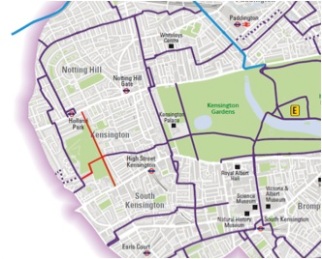
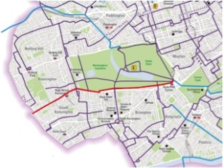
A grid is defined as “a network of lines that cross each other to form a series of squares or rectangles”. The Bike Grid is described by Boris Johnson as “a new network of routes” and by TfL as “a connected, safe set of routes taking cyclists across central London”. A quick look at the map of proposed routes shows that, by and large, it does indeed consist of a series of parallel north-south and east-west routes that connect to form a grid. The glaring exception though is in the Royal Borough of Kensington and Chelsea (RBKC), where many of the proposed routes come to a sudden end without connecting. There is no continuous east-west route proposed at all north of the convoluted route through South Kensington and no sign of the promised east-west Cycle Superhighway through the borough. 

Boris Johnson promises of the Bike Grid that “unlike some cycle routes in the past, they won’t give up at the difficult places.” Unfortunately, in RBKC, giving up at the difficult places is exactly what the planners have done:

 Image

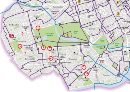
Proposed Bike Grid in RBKC – incomplete and unconnected.

When challenged with this criticism, the borough’s Chief Transport Policy Officer responded that

where routes do not join up to other routes,they are spurs added to the proposed core network to connect either to existing cycle routes – as at Holland Walk –  or to cycle hire docking stations or Tube stations.

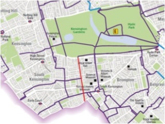
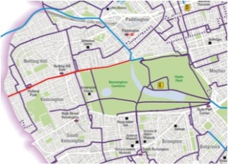
This is utter nonsense: why would Holland Park tube station be anyone’s destination for a journey by bike, when bikes are banned from the Central Line? What is the point of connecting to existing routes such as Holland Walk or Broad Walk, when these routes themselves do not connect to continuing routes? Such “spurs” are mentioned nowhere in TfL’s Bike Grid consultation document and are not proposed in any other borough. They are nothing more than a poor excuse by RBKC for a proposal which is so insubstantial compared to the other boroughs that those involved should be embarrassed by it. If these so-called “spurs” are removed from the map, then the proposed grid in RBGK looks like this, pathetic compared to the proposed grid of connected routes in other boroughs:

Image

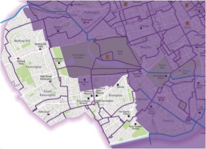
Map with only routes that connect shown: routes in Kensington and Chelsea are very sparse compared with all other boroughs.

A generous interpretation of this map is that there is one continuous north-south and one continuous east-west route through the borough, but the rest of the borough is entirely neglected.

Rather than labelling the unconnected routes as “spurs”, surely a better approach would be to connect them properly to the grid. It is not difficult, but the transport planners at RBKC seem to be incapable of it, so here is a guide for them to the “missing links” needed to turn the “spurs” into a properly connected grid.

If all these missing links were complete, the Bike Grid in Kensington and Chelsea would look very different, would provide a safe environment for encouraging increased cycling in the Borough and would be an achievement the Council could be proud of:

 Image

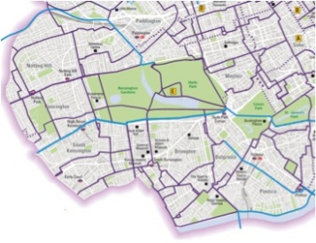
What the Bike Grid should look like in Kensington and Chelsea, as a minimum.


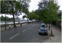
The Missing links: Chelsea Embankment

 Image

Management:                                    TfL (Red Route)

Total motor traffic                  34,822 vehicles per day:

HGV traffic                                    2,035 vehicles per day:

Pedal cycle traffic                  2,456 pedal cycles per day:

Exiting cycle route:                  National Cycle Network Route 4

Existing facilities:                  Shared use pavement only

In February 2013, TfL consulted on proposals to improve conditions for cyclists and pedestrians on Chelsea Embankment, including some advisory cycle lanes “where feasible”. Unfortunately it was a very poor design, with cycle lanes only where the existing lanes are wide enough to accommodate them, but intermittent and disappearing at junctions.

TfL received 31 responses to the consultation. According to the consultation summary, the main issues raised were:

  • “Concerns about the proximity of the cycle lanes to the parking spaces along Chelsea Embankment. Can the parking spaces be removed?
  • The pavement is too narrow to accommodate the existing shared space, especially with the street furniture and trees there as well.
  • The proposed cycle lanes are too intermittent and disappear at key points leading up to junctions.
  • The proposed cycle lanes should be mandatory rather than advisory as the proposal gives no protection to cyclists.”

Following the consultation, rather than improving the design, TfL decided to scrap the proposed cycle lanes entirely.

“The decision to delay implementing the cycle lanes follows the publication of the Mayor’s Vision for Cycling in London. Our focus is to deliver a planned network of cycle routes throughout the city, and we need to give further consideration as to how the proposed cycle lanes on Cheyne Walk / Chelsea Embankment fit in with this Vision.”

It is puzzling therefore that the proposed Bike Grid has been published, but no cycle route is proposed on Chelsea Embankment.

TfL is correct that there is a need for a safe cycle route along Chelsea Embankment (and Cheyne Walk). No other straight east-west route is available between the Embankment and Hyde Park, and it provides access to the excellent CS8 into Westminster. The current shared use pavement is not fit for use as it is an uneven surface and virtually impossible to access or exit safely.

TfL was also correct to scrap the previous poor proposal but now is the time to come up with something better, to integrate this route into the Bike Grid, and do it properly by removing the dangerous car parking and installing compulsory cycle lanes in each direction.

This is an excellent example of an area where quiet backstreets simply are not available for east-west journeys, and so the Bike Grid must make use of segregated cycle lanes on main roads instead.

Image    

Most of Chelsea Embankment has room for segregated cycle lanes.                             

Image 

Car parking is a hazard to cyclists in places, and needs to be relocated or removed.


The Missing Links: Holland Park

Image 

Management:                                    RBKC

Existing cycle route:                  Holland Walk

Existing facilities:                  Shared use path through park

It is odd that the existing north-south cycle route through Holland Park, along Holland Walk, is not included in the proposed Bike Grid (existing routes through other parks are shown). Perhaps it is because currently it does not connect with continuing routes at either end. Cyclists arriving at Holland Park Avenue at the north end are greeted with a metal barrier and a “cyclists dismount sign”. Turning right from Notting Hill Avenue (eastbound) into Holland Walk is an impossible manoeuvre, as is turning right from Holland Walk into Holland Park Avenue.

It is the same story at the south end, with no legal way for cyclists to turn right from Kensington High Street (westbound) into Holland Walk, or left from Holland Walk into Kensington High Street.

All that is required (as a minimum) is a toucan crossing and small area of shared use pavement at each end of Holland Walk, so that cyclists can enter and exit Holland Park safely and legally.

Even worse is the complete lack of provision for crossing Holland Park east-west by bicycle. Bizarrely, the proposed grid shows routes leading to the east side and west side of the park, but no route through the park linking them. This “missing link” prevents would otherwise be a complete unbroken east-west route from Kensington Olympia in the west to Westminster Bridge in the east.

It is difficult to understand why an east-west route through Holland Park has not been proposed as part of the Bike Grid, given how easy it would be to achieve.

Even the Council’s own Holland Park Management Plan 2006-2016 states:

“Cyclists are forbidden under the existing bye-laws of the park–yet enforcement of the policy is both impractical and at variance with wider sustainable transport policies of government, the Mayor of London and the Council. The Parks Police patrol on bicycles and Council officers are being encouraged to follow suit…but the public remains discouraged from doing so. This needs urgent re-appraisal and a move to the American system that gives pedestrians right of way and consideration on public footpaths should be evaluated.”

Actually, there is no need to look to America – considerate cycling has been successfully permitted in parks in other London Boroughs such as Southwark and Lambeth for years.

Nor is there any need to make all paths in the park shared use, if Council officials remain concerned about potential conflict between cyclists and pedestrians. Only 200m of cycle track are required to complete the link. Simply by moving one of the entrances to the sports field, the existing path around the northern fence of the sports field could be converted to a segregated cycle track, which would result in virtually no conflict with pedestrians:

 Image

Two options for a cycle route across Holland Park: shared use path (blue) or segregated track along the north side of the sports field (red).


The Missing Links: Queen’s Gate

 Image

Management:                                    RBKC

Existing cycle route:                  none 

Existing facilities:                  Link with South Carriage Drive

On Queen’s Gate can be found Imperial College’s main cycle parking facility as well as the staff cycle entrance for both the Science Museum and the Natural History Museum and no less than five Cycle Hire docking stations. It connects at the north end with South Carriage Drive in Hyde Park (even with dedicated cycle traffic lights), and with the proposed Bike Grid at Queen’s Gate Place and Harrington Road. It is odd then that Queen’s Gate itself is not included in the proposed grid.

The current problem with Queen’s Gate is that despite resembling a giant car park, with four rows of parked cars along its length, the road is still very wide, which encourages cars to drive at high speed. The road markings at junctions encourages traffic to use two lanes, which squeezes cyclists between parked cars and fast-moving traffic, increasing the risk of being hit by a car door and making it dangerous to change lane in order to access the Cycle Hire docking stations on the central reservation, or to turn right.

Queen’s Gate is primarily a residential street, and there is no need for two lanes of traffic in each direction. There is plenty of road space to introduce a generous cycle lane in each direction. If two lanes of traffic are required at junctions, this could be maintained simply by removing a small amount of parking along the central reservation at junctions. Apart from that, there would be no need to remove car parking – although it may be safer to run the cycle lanes behind parked cars (and bus stops).

There is also an urgent need to improve the provision for cyclists turning right from Queen’s Gate (northbound) into Museum Lane, Imperial College Road and Prince Consort Road, and for southbound cyclists to turn right into Queen’s Gate Place.

This route could also be continued along Old Church Street as a direct north-south Quietway, linking Hyde Park with the river at Cheyne Walk.

 Image

Plenty of space for car parking as well segregated cycle lanes on Queen’s Gate.


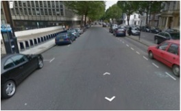
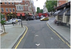
The Missing Links: Kensington High Street and Cycle Superhighway 9

Image

Management:                                    RBKC

Total motor traffic                  21,361 vehicles per day:

HGV traffic                                    780 vehicles per day:

Pedal cycle traffic                  2,913 pedal cycles per day

Existing cycle route:                  None

Cycle Superhighway 9, due to run between Hounslow and Hyde Park, is conspicuous by its absence from the Bike Grid map. TfL’s website still says it is due to open in 2014 – though this seems unlikely!

Image

It seems that plans for CS9 have been abandoned, because RBKC have blocked TfL’s proposed segregated cycle lanes along Kensington High Street, not because of any sound argument, but because they are intransigent in their belief that, to quote the Council Leader “no one form of travel should be considered over all others” and therefore that cycles should mix with motor traffic. This is particularly galling for the residents of Hounslow who will now not get a safe route into central London, because RBKC will not allow it safe passage through the Borough.

It is clear from the map of the proposed Bike Grid that there is a need for a safe cycle route along Kensington High Street from Hammersmith to Exhibition Road, to enable people to choose to travel by bike from West London into the city centre.

Kensington High Street is a wide road and there is no reason why space cannot be allocated to cyclists here, as has been successfully achieved on Grosvenor Road and Millbank (which carries more traffic), where road space has been re-allocated to Cycle Superhighway 8 without adversely affecting motor traffic too much.

On Kensington High Street the carriageway is, on average, 16m wide. It narrows twice to 11m (at Earls Terrace, and at the Royal garden Hotel) and widens to over 20m in places. The London Cycle design standards recommend a minimum width for a two-way cycle track of 3m, but 4m where space permits.  Even at these two “pinch points” there is still room for a 4m cycle track and a single 3.65m lane for motor traffic in each direction. Where the carriageway is the average width of 16m, there would be space for a 5m wide two-way cycle track, plus a single 3.65m lane for motor traffic in each direction and a further 3.7m which could be an extra lane, or space for bus stops or loading bays. In the places where the carriageway is in excess of 19m wide, there is space for a 5m cycle track plus four 3.65m traffic lanes.

RBKC seem to be particularly concerned that a segregated route could not be designed without threatening the safety of pedestrians or bus users. Routing cycle tracks on the inside of bus stops would be hugely beneficial to the safety of cyclists, with only small inconvenience to pedestrians, and is standard practice in the Netherlands. Space is reallocated from the road, not the existing pavements, so there would be no reduction in pavement width.

Furthermore, the Transport Research Laboratory has been asked to carry out a trial of bus stop bypasses on behalf of TfL, to investigate the best configuration to minimise conflict between cyclists and pedestrians crossing between the main footway and the bus stop island. Different layouts are being tested under different levels of pedestrian and cyclist flows taking particular account of pedestrians with impaired vision or mobility. RBKC should not rule out segregated cycle lanes without even considering the results of these trials.

Image

Kensington High Street: pedestrians are able to dodge the traffic to scurry across at will, but could not manage to safely cross a cycle track?

As a pedestrian, I find it bizarre that RBKC should think that removing lanes of traffic and replacing them with cycle tracks should make the environment worse for me. It is the congestion, noise, pollution and risk of injury produced by four lanes of motor traffic which makes the environment hostile and off-putting to shoppers. It is odd that the council seems to be proud of the fact that pedestrians are able to scurry across four lanes of traffic, if they can dodge the cars, busses and lorries in time, at will but would be unable to negotiate crossing two cycle lanes.

There is also plenty of evidence that if the council moved to discourage through traffic from Kensington High Street, and encouraged cyclists into the area, that local businesses would benefit financially.

RBKC therefore needs to work with TfL to make Cycle Superhighway 9 a reality.


The Missing Links: Holland Park Avenue/Notting Hill Gate/Bayswater Road

 Image

Management:                                                      RBKC

Total motor traffic (average)                  27,795 vehicles per day:

HGV traffic (average)                                    857 vehicles per day:

Pedal cycle traffic (average)                   2,239 pedal cycles per day:

Exiting cycle route:                                    None

A route from Holland Park roundabout, along these roads as far as the Broad Walk on Kensington Gardens (and continuing, under Westminster Council’s control, as far as North Carriage Drive) would provide a much–needed east-west route to the north of the borough, as well as connecting some of the proposed unconnected routes. It is another example of an area where suitable quite back streets do not exist, so the Bike Grid must use segregated facilities on main roads instead. This wide, tree-line boulevard consists of a minimum of four lanes of traffic through most of its length.

ImageImage

Holland Park Avenue and Notting Hill Gate: currently hostile to cyclists, but plenty of room for segregated cycle tracks.

The average daily traffic flow along this road in 2012 varied from 27,547 to 28,343 motor vehicles per day (depending on the section measured). Grosvenor Road between Chelsea Bridge and Vauxhall Bridge, which was recently reduced from two to one lane of traffic in each direction to accommodate generous cycle lanes for CS8, has higher traffic flows (30,191) yet the reduction to a single lane has not resulted in any significant congestion. There is scope therefore to re-allocated road space on Holland Park Road, Notting Hill Gate and Bayswater Road to accommodate a segregated cycle lane in each direction similar in style to the new segregated route along Stratford High Street. This could be flagship cycle project for RBKC, which is currently planning improvements to Notting Hill Gate. 


The Missing Links: Chelsea Bridge Road.

Image


Management:                                    RBKC /City of Westminster

Total motor traffic:                  14,587 vehicles per day

HGV traffic:                                    363 vehicles per day

Pedal cycle traffic:                  5,155 pedal cycles per day

Exiting cycle route:                  LCN 5


Chelsea Bridge Road links the proposed “Circle Line” route with the existing Cycle Superhighway 8 and already has segregated cycle lanes along most of its length, so it would make sense to include it in the Bike Grid. It is already used by a very high number of cyclists – over 5,000 per day on average.

The only problem at the moment is the junction of Chelsea Bridge Road and Grosvenor Road. Currently, it is impossible for cyclists travelling westbound along CS8 on Grosvenor Road to (legally) turn right into Royal Hospital Road (despite TfL’s Journey Planner often recommending this turn as part of its suggested cycling routes).

Currently, a toucan crossing allows cyclists wishing to turn right to cross Grosvenor Road onto the north pavement. However, there is no equivalent facility to cross Chelsea Bridge Road. Conversion of this crossing to a toucan would enable the turn to be completed by bike.

Even better would be a simple facility for performing a right turn, such as that found on Vauxhall Bridge, which combines toucan crossings with a short section of segregated cycle track on one side, and an area on the central reservation adjacent to the crossing for cyclists to wait to complete the turn.

For cyclists on Chelsea Bridge Road (southbound), the cycle lane needs to operate around the clock, and continue all the way to the advanced cycle box at the junction (behind the bus stop and disabled parking for the Lister Hospital if necessary).

Image 

(L) Facility enabling cycles to turn right from Albert Embankment onto Vauxhall Bridge. (R) Similar facility required at Grosvenor Road/Chelsea Bridge Road.


The missing links: Sloane Square.

 Image 

Boris Johnson promises of the Bike Grid that “unlike some cycle routes in the past, they won’t give up at the difficult places.” Unfortunately, the planners of the Bike Grid do seem to have given up at Sloane Square. All that is required to complete the missing link is:

  • Close Sedding Street to motor traffic. The south end of Sedding Street could become a paved shared space for cyclists and pedestrians, with more space for outdoor seating outside the Botanist.
  • The entrance to Holbein Place from Sloane Square in front of the tube station creates conflict between pedestrians and motor vehicles, and should be closed to motor traffic.
  • Relocate the bus stand outside the Royal Court Theatre, and create a section of two-way segregated cycle track running along the east side of Sloane Square connecting Sedding Street with Holbein Place.

Image Image

Close and re-landscape end of Sedding Street, replacing zebra with toucan crossing. Relocate the bus stand and replace with two-way segregated cycle track.


Preliminary Ward Asks

With the delightful feedback that we’ve had on the LCC 2014 elections survey, we’ve come up with our specific asks per electoral ward in K&C. For a wonderful representation of these on a map and zoom in to K&C. It’s been pretty hard to narrow down to one specific ask, but we think that this is the best single pressure point that all road users deserve in the borough.

More details to follow over the coming months but do you agree? Also, if you do and want to take a picture, please do put it in the comments!

Ward Name Ward Ask Theme Specifc Ward Ask 
Abingdon Liveable Town Centres Reduction of high vplume of traffic and more relaxed streets for all users particularily on Wrights Lane and Marloes Rd
Brompton & ‘Hans Town Liveable Town Centres Surrounding South Kensington Tube, current links (to exhibition road especially) are congested and not inviting
Campden Protected Space for Cycling CS9 is a crucial part of allowing kensginton and chelsea to have real permeability and stop it being a dead end for cycle routes and safety
Colville Protected Space for Cycling Ladbroke grove is in need of a redesign, current routes like 45 are not used as they do not allow high volumes and have poor filtering into smaller side roads. Ladbroke drove will allow passage and stop this area being cut off by hostile roads
Courtfield Safe Routes to Schools Improve condition and infrastructure of old brompton road in order to make schools safer to travel to and from, as well as improving the Evelyn Gardens contra-flow for the same reason
Cremorne Protected Space for Cycling Need to link up to cycle superhighway 2, links to bridges: thames bridges protected spaces especially need to have either Albert Bridge or Battersea bridge
Earl’s Court Protected Space for Cycling Plan safety of HGVs access to Earls court rebuild to crossrail levels or better and a lasting legacy of safely protected routes in this area
Golborne Protected Space for Cycling Ladbroke grove is in need of a redesign, current routes like 45 are not used as they do not allow high volumes and have poor filtering into smaller side roads. Ladbroke drove will allow passage and stop this area being cut off by hostile roads
Holland Greenways Making holland park cycle friendly will make the london grid useful and accesible as a quietway
Norland/ Notting Dale Liveable Town Centres In order to link up with cycle cross rail and make it effective as well enhancing permeability/links for schools inside and outside of this ward
Notting Barns/ St Helen’s 20 mph Discourage and reduce high speed traffic through latimer road will create a safer and more pleasant environment
Pembridge Protected Space for Cycling Providing clear space through notting hill gate, review car parking heading westbound as this forces cyclists into traffic
Queen’s Gate Liveable Town Centres Busiest part of route from High Street Kensington and Kensington Rd, and should be made more accessible for the community
Redcliffe Safe Routes to Schools In partiular the junction of old brompton rd and bolton gardens is very tight and there are several problems with HGVs and children crossing for school
Royal Hospital Liveable Town Centres Sloane Square needs to be accessible as the town centre that it is, currently inhospitable to all road users
St Charles Areas Without Through Motor Traffic Take community-centric approach to streets, in particular brewster gardens to dalgrno gardens in order to truly calm streets
Stanley Areas Without Through Motor Traffic Dovehouse Street and cale street have high flow through, suggest removal of one way for cyclists on both, create car free zone for safety of patients

Grid response for K&C

After much debate over the last month or so the K&C LCC group had some to an official response to the LCC grid proposal for our borough. This is what we are sending to both TLF and Kensington and Chelsea as a part of the feedback process

Overall Feedback

We are grateful to Kensington and Chelsea along with TFL for the cycling grid plans. Overall there is a lot of potential for the cycling grid to deliver a much safer and more pleasant experience for all road users. It is slightly dissapointing that our neighbour borough in the grid has outshone Kensington and Chelsea in their proposal. Whilst Westminster have produced a 50 page document to give a background to their proposal, choices for routes and their vision; Kensington and Chelsea have given a 7 paragraph piece of text on their website and linked to the tfl grid information. As it stands, many of the proposed routes currently do not link up with any cycle route in hammersmith and fulham, leaving us hoping that there will be routes joining up to our neighbour boroughs rather than ending abruptly (and not being used for that reason).

Kensington and Chelsea have decided to self-impose a restrinction of their grid design to that of only quietways, leaving a clear lack of east-west routes that would be able to cope with the large numbers of commuters through the borough. We believe leaving out Cycle Superhighway 9 has likely ruined the grid as a whole for any cyclist wishing to travel between central london and west london. A separate cycle lane along one of the main roads is needed to facilitate east-west travel.

The south east of Kensington and Chelsea is well covered by the grid, which we are pleased with. However, there is a need for a route through Brompton. More pressingly though, is a need for a high quality route along the embankment. The idea of the grid is to allow cyclists to pass throughout London, following this it is expected that each bridge should be covered as well as points adjoining them.

We believe the feedback given in this document to be a realistic critique to the current grid, and hope that it will aid in adjusting the current plans to make them a worthwhile investments in our streets.

Stressing East-West Need

We would like to highlight that east-west travel is essential for those who live in our borough and those who commute though it. Current suggestions don’t join up with hammersmith and fulham which we hope will be rectified either in either borough. In addition to CS9 we suggest that Holland Park Avenue – Notting Hill Gate – Bayswater road is another option. We see no justification for Kensington and Chelsea’s self-imposed restriction to quiet ways.

Finally, we hope that all grid plans are well integrated with Hammersmith and Fulham, as it stands none of the grid links up to current routes into this borough which is worrying to say the least.

Route Specific Feedback

K&C Grid

Route 1: Westbourne Park Rd – Cornwall Crescent – Clarendon Rd

A: St. Marks Rd

  • Serves Thomas Jones Primary school
  • Issues: Does not link up with any current cycle route

B: Clarendon Rd + Lansdowne Mews – Lansdowne Rd

  • Regularly used roads for cyclists and covers cyclehire point
  • Issues – Ends on Holland Park Avenue without a route going along this road

C: Portland Rd – Walmer Rd – Princedale Rd – Queensdale Rd – Norland Sq x Holland Park Ave x Abbotsbury Rd – Melbury Rd

  • Also regularly used road
  • Currently this route or the alernative suggestion do not link up with any current cycle route

Route 2: Studio Walk – Palace Ave – York House Pl x Kensington Church St x – Holland St – Duchess of Bedford’s Walk

  • We expect this route to be two way for its entirety, also current barriers to the exit of kensington gardens should be removed to make it a comfortable and chosen route.
  • Narrower streets (especially around church st) are going to be difficult to manage – currently if a large vehicle is on the street they are impassible, space for both cyclists and pedestrians needs to be considered
  • Success of route will depend on quality of route – how well will throughtraffic and parking be removed
  • Concern over whether people will choose to use this route and whether it will be able to cope with number of cyclists that pass east to west.
  • Assume this route takes you through Holland Park, but as with route 1:C does not lead to another route afterwards.

Route 3: x Bayswater Rd x Kensington Palace Gardens x Kensington High St x Road leading to Kensington Ct – Kensington Ct – Kensington Ct Pl – St Albans Grove – Victoria Grove – Lauceston Pl

  • Useful North south link
  • Intervention crossing Bayswater rd and that of Kensintington High St will need to be of high quality

A: Cornwall Gardens – Queen’s Gate Gardens – Queen’s Gate Pl

  • Does not link to Imperial College Rd, or Prince Consort Rd could have served Imperial College, Royal College of Music
  • Need to manage entry onto Queen’s Gate, fast traffic and aggresive road
  • Does not link up with any other current route

B: Lauceston Pl – Grenville Pl x Cromwell Rd x Ashburn Pl

  • Useful linker to route 4

C: Cornwall Gardens – linkers – Lexham Gardens x Pembroke Rd x Logan Pl – Cornwall Crescent – Cromwell Rd

  • Cromwell rd has the potential to be useful if done at high quality, if not it has the likelihood to be very dangerous
  • Route does not carry on to any current route, it is our hope that this would be linked up by another high quality and segregated route from hammersmith and fulham.

Route 4: Earls Court Sq x Earls Court Rd x Bramham Gardens – Collingham Gardens – Harringston Gardens – Stanhope Gardens – Harringston Rd – Thurloe Pl

  • Generally a well-placed route, success will depend on the route being well thoughtout.
  • Route appears to start on Warwick Rd, for crossing Earls Court Rd – high quality crossing required, the current configuration for crossing Earls Court Rd needs a definite rework.

A: Collingham Gardens x Old Brompton Rd x

  • Does not link up with current north-south route along Drayton Gardens – Vale St.
  • Potentially a useful route if new routes in hammersmith and fulham are well placed and joins up, currently does not connect with any route.

Route 5: Exhibition Rd x Cromwell Rd x Exhibition Rd – Thurloe St

  • Exhibition road looks a lot more pleasant but is a frightening experience for cyclists. Current 20 mph is ignored and problems with being cutt off at the roundabout junction. Hard to take the lane where there is no lane marking, frankly drivers don’t seem to slow down in this unusual environment as they have done in smaller towns implementing this throughout.
  • Crossing Cromwell Rd there is still confusion with drivers heading south thinking that it is one way, this will need to be rectified and space given to cyclists.

Route 6: Reece Mews + Bute St – Sumner Pl x Fulham Rd x Dovehouse St x King’s Rd x Oakley St x Chelsea Embankment

  • Dovehouse St is of particular concern for lack of space for cyclists, currently at the south side cyclists are already being pinched for space, will this be cut off with bollards or the parking taken out?

Broadwalk in Kensington Gardens

  • This route does not connect with any cycle route at the north or the south, leading us to question why is included.

Do we really need another corporate sponsor for London’s Cycle Hire scheme?

Few will lament the end of the association of Barclays with the Mayor’s cycle hire scheme. Despite the promise of £50m sponsorship, barely half of that has emerged. Barclays logos have been lavishly splashed across London’s streets, while the bill for installing the ‘Boris bikes’ has in fact been left to councils, and users who have seen fares double in the past year.

If we are to learn from the mistakes of the past we must ditch the idea that essential public transport options, which cycle hire is, should be paid for by private sponsorship. We don’t have the ‘Lloyds Underground’ or ‘Virgin DLR’ for good reasons. If cycle hire is worth investing in (which I believe it is) it should be funded centrally from TfL’s budget, and, crucially, integrated with other transport options. In the short term this may mean Londoners pay more for the bikes, but with the result that London gains a city-wide affordable cycle scheme giving all of us the chance to travel sustainably and healthily, and, dare I say, with a bit more fun that a crowded train carriage.

Written by regular K&C cyclist, iloveBorisBikes.com

London Cycle Hire in Kensington and Chelsea

Boris Bikes in the Royal Borough – a Story of Success?

Cycling in Kensington and Chelsea has its problems, but one success story is the roll-out of cycle hire across the borough. From Friday 13 December 2013, virtually the whole borough has had ‘Boris bikes’ available to hire, bringing the joy of cycling to the doorsteps of residents, workers and visitors.

A Short History

K&C is a central London borough, much of which lies in zone 1. It was natural therefore that it would be included in the first phase of the Mayor’s flagship cycle hire scheme. In 2010 docks were rolled out as far west as Holland Park and Notting Hill Gate. Among the most popular docks were those located close to the museums in South Kensington, at Imperial College, and of course those in Kensington Gardens.

Expansion continued quickly; when Exhibition Road’s new layout was unveiled (a complete – and very costly – failure for cyclists and pedestrians), it included two new docking stations. Then in April 2012, when the ‘eastern extension’ of the cycle hire scheme went live, this also included a small western extension as far as the Westfield shopping centre, partly funded by Westfield itself. Four stations were installed on the Westfield estate, and in addition new docks were added on Notting Hill and in the Holland Park area, plus Notting Hill Gate dock was extended.

The 2013 ‘southwestern’ extension was the opportunity to finish the job, by adding new docking stations to the south (in riverside Chelsea) and to the north (North Kensington contains many of the borough’s poorest wards). Docking stations intensified along the arterial Holland Park Avenue with new docks at Holland Park station and on the corner of Princedale Road. Kensington and Chelsea is now ‘central’ to the cycle hire scheme, having H&F to the west, Westminster to the east, and Wandsworth to the south.

Barriers to Success

There are some physical constraints which the borough experiences which constrain he success of the scheme; Notting Hill and Campden Hill are both fairly steep, tending to mean more bikes come down than up. But most of the barriers to cycling in the Royal Borough are due to inherently unsafe road conditions (i.e. structural). I won’t repeat material which is elsewhere on this blog, but safer cycling conditions particularly on arterial routes such as Kensington High Street and Notting Hill Gate are needed to get the borough on their Boris bikes. Queen’s Gate could be a superb north-south route, and has many docks, but is currently marred by high vehicle speeds and cluttered car parking. Kensington Gardens lacks capacity at its two docking stations, and there is no safe route along the north of the park between Queensway and Lancaster Gate gyratory (which needs to be removed anyway).

For the Future?

Kensington Gardens and the Imperial College / Museum Quarter need more docking stations to improve capacity. Bizarrely, groundwork was done right outside the V&A Museum, but docks never installed. But most of the work has been done – now Kensington and Chelsea needs a better and safer network of segregated cycle routes at 20 MPH to promote the use of cycle hire in the borough.

Kindly contributed by our local Boris Biker and author of the ILoveBorisBikes blog.

Related articles

RBKC’s Notting Hill Gate consultation report

RBKC Council have published their Notting Hill Gate consultation report. Despite many respondents calling for proper, safe, dedicated space for cycling at this atrocious and horrible junction, segregated cycle lanes have been completely refused by Cllr Coleridge and the rest of the Council. The document says that some nearside lanes will be widened ‘for cyclists’, but this could easily make things even worse for those on bikes by encouraging motorists and buses to overtake in the nearside lane rather than changing lanes in order to overtake vulnerable road users (the far safer option).

Sickeningly, given their refusal to make this key junction safe for cycling, the Council have also used images of the ghost bike for Eilidh Cairns, killed by an HGV driver while cycling through Notting Hill in 2009, as part of the consultation document.

Image

Image from the consultation document that seems to be showing off the terrible fact that Notting Hill Gate contains a ghost bike in memory of Eilidh Cairns

The only result of the Council’s decision not to segregate this junction will be more Londoners, like Eilidh, being killed while they cycle through it. We are deeply disappointed. Perhaps the Council are simply seeking to acquire more ghost bikes for publicity purposes.

Here are a few submissions by residents that the Council chose to ignore, as well as our advice as the RBKC branch of the London Cycling Campaign (LCC):

ImageImage

Many thanks to @nuttyxander for highlighting this report and the submissions.

This is a link to the London Tonight report on the installation of the ghost bike in memory of Eilidh Cairns in 2009. Amazing how little has changed since then.

RBKC, Kensington High Street, and Cycle Superhighway 9

This has been a terribly sad week for cycling in London, with five cyclists suffering the worst kind of violent death imaginable in the past nine days. Since it opened, four cyclists have now been killed on Cycle Superhighway 2 alone, including yet another fatality last night coming only a few weeks after coroner Mary Hassel described CS2 as “’an accident waiting to happen”.

On Thursday 14th November, deputy Prime Minister Nick Clegg said “distressing as all this is, I really hope it doesn’t discourage people from bicycling – it’s got to be made safer and we have got to have more of these bicycling superhighways which physically separate cyclists from roads.”

Nick Clegg is correct. The only way to encourage cycling, but to eliminate these horrendous deaths, is to physically separate cyclists from HGVs and fast moving traffic on busy main roads, especially at junctions, and to remove through traffic and improve permeability for cyclists on quiet back streets.

RBKC has made some progress on the latter, but in previous communication with the Council, Cllr Nicholas Paget-Brown and Cllr Timothy Coleridge have both made it abundantly clear that they have a fundamental objection to providing segregated cycle facilities, even on busy main roads, because this usually involves reallocating road space to cyclists which they see as “considering one form of transport above all others”.

We sincerely hope that the events of the past nine days will make the Council reconsider their heartless position.

Cycle Superhighway 9 is currently in the planning stage. We want the Council to work with TfL to ensure that this route, as it passes through RBKC, is well designed and keeps cyclists safe by allocating road space to physically separate people travelling on bikes from lethal HGVs. Nicholas Paget-Brown and Timothy Coleridge have the power now to prevent deaths like those of the past week happening in the future.

Instead the Council is currently choosing to obstinately refuse permission for TfL to build the segregated route which Andrew Gilligan and Boris Johnson want to create. We would very much like to see this to change.

20 MPH for the Royal Borough

We strongly feel that  RBKC Council should introduce a 20 MPH borough-wide limit excluding certain main roads.

There is huge amounts of evidence, including from the British Medical Journal and Royal Society for the Prevention of Accidents, that 20 MPH limits and zones can significantly reduce the amount of people who are killed or maimed in road traffic accidents on our streets.

It is, therefore, equally clear that a 20 MPH limit for the borough would do a huge amount to making residents feel safer cycling and consequently increase cycling rates in the borough.

Camden, Islington, Hackney, Southwark and the City of London all have a borough-wide 20 MPH limit or a significant majority of roads at 20 MPH. It is no surprise that these boroughs also ‘coincidentally’ have higher rates of cycling than the 30 MPH Royal Borough.

Even our neighbours in Hammersmith and Fulham have significant areas of 20 MPH on dense residential streets and around schools.

Far from instituting a borough-wide limit, our current council led by Nicholas Paget-Brown (with Timothy Coleridge responsible for Transport) will not even consult residents on their right to have 20 MPH limits outside schools and along routes where kids can cycle or walk to school. We feel this is abominable and would like to see the Council change its position or the councillors changed at the 2014 elections.

60% of households in the Royal Borough are now car-free. In maintaining a 30 MPH default limit against the advice of the Mayor’s Roads Task Force, the current RBKC Council is privileging the convenience of the minority of residents who choose to drive at 30 MPH on residential streets where it is dangerous to do so, over the safety and lives of the majority of residents who choose to walk or cycle as part of their daily journeys. That isn’t a democracy. And, far more tragically, it continually results in a needless loss of life and suppression of cycling levels.